In the high-stakes world of Western Wisconsin land sales, a trail camera photo of a 170-inch buck is no longer enough to command a top-tier premium. Serious buyers want to see the engine behind the antlers, and standard ground shots simply cannot capture the intricate scale of your bedding thickets or the precision of your food plot layout. This guide on Wildlife Photography on Your Property: Marketing Tips from Drone Experts will show you how to bridge that gap. You already know that your land management efforts are superior, but without the right perspective, you’re leaving money on the table because buyers can’t visualize the full potential of your Bluff Country acreage.
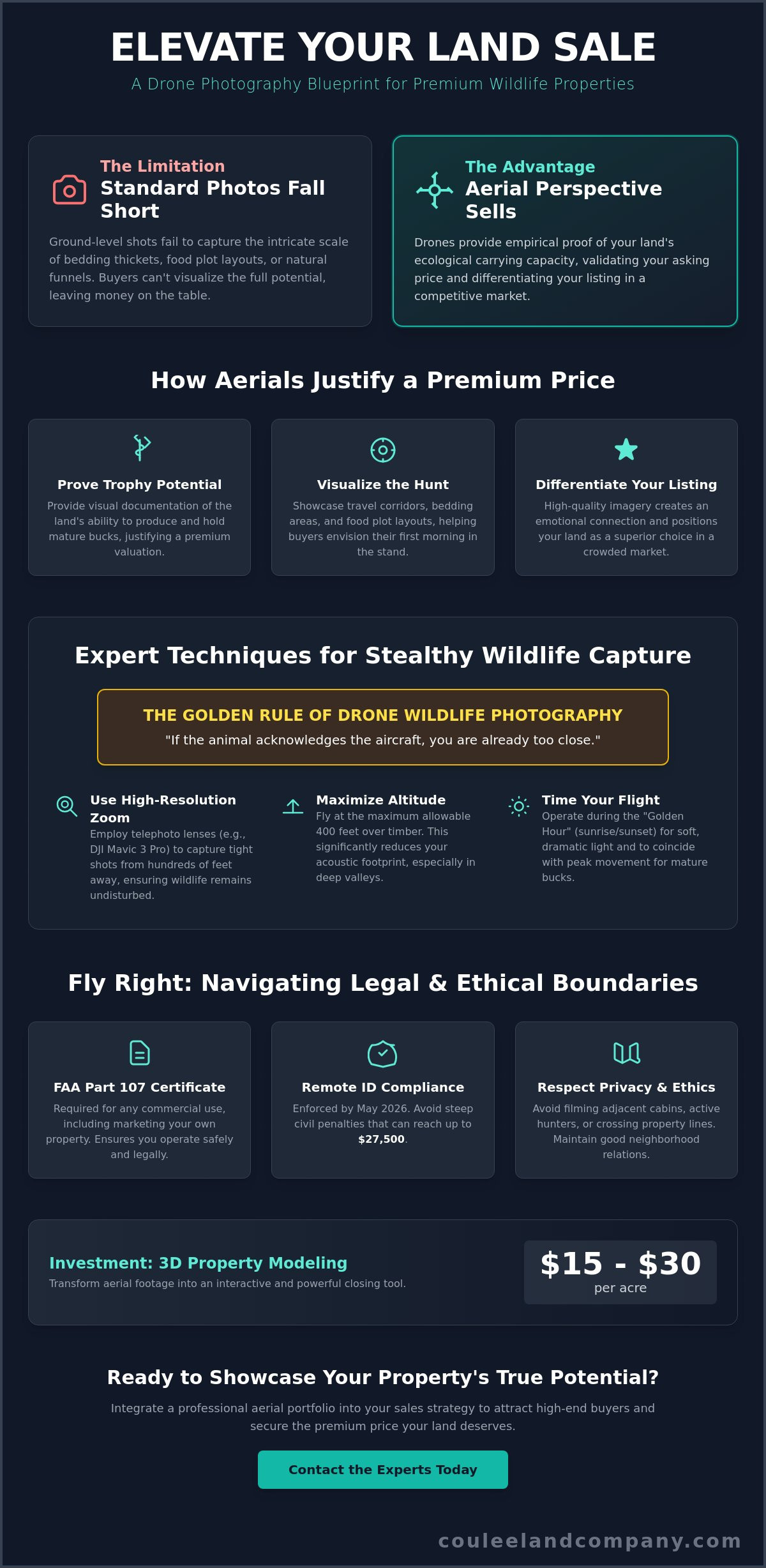
We’ll show you how to use advanced tools like the DJI Mavic 4 Pro and its multi-camera system to document your property’s success without spooking mature bucks. You’ll learn how to stay compliant with May 2026 Remote ID enforcement and FAA Part 107 regulations to avoid civil penalties that can reach $27,500. We’ll outline how to build a high-quality aerial portfolio that speaks the language of high-end recreational buyers and justifies a premium market price. From understanding the $15 to $30 per acre cost for 3D modeling to navigating privacy laws, this article provides the blueprint for turning aerial footage into a powerful closing tool.
Key Takeaways
- Learn how to transform your property’s ecological carrying capacity into a visual asset that justifies a premium market valuation.
- Master stealthy flight techniques using high-resolution zoom lenses to capture mature bucks without disrupting their natural patterns.
- Follow these Wildlife Photography on Your Property: Marketing Tips from Drone Experts to storyboard your land, moving from sweeping bluff views to intimate food plot details.
- Integrate high-quality aerial portfolios into your broader sales strategy to attract high-end recreational buyers looking for proven trophy potential.
The ROI of Wildlife Imagery: Why Aerial Perspectives Sell Land
In the competitive market for recreational acreage, wildlife property marketing is much more than a collection of pretty pictures. It’s the visual documentation of a property’s ecological carrying capacity. When you’re listing Wisconsin hunting land for sale, capturing a mature buck on-camera does more than create excitement; it provides empirical proof of the land’s value. This perspective validates your asking price by proving the habitat can produce and hold the kind of trophy whitetails that Buffalo County is famous for.
The famed Bluff Country of Western Wisconsin demands an aerial view. Standard ground-level photography fails to capture how a deep ravine acts as a natural funnel or how a specific ridge top serves as a primary travel corridor. By using advanced wildlife photography techniques, you help a buyer visualize their first morning in the stand. They aren’t just looking at dirt; they’re seeing the strategic layout of a hunting sanctuary.
To better understand how to capture these high-impact shots, watch this helpful video:
Visual Proof of Land Management Success
Drones offer the only way to truly showcase the transition zones between food plots for whitetail deer and thick bedding cover. This bird’s-eye view of water sources and mineral sites builds immediate buyer confidence. It demonstrates that the land management plan is active and effective. Seeing the relationship between a lush clover field and a south-facing cedar thicket allows a buyer to verify the property’s wildlife capabilities without stepping foot in the woods.
Differentiating Your Listing in a Competitive Market
Professional-grade wildlife stills are essential for high-end land brochures. These images allow you to move beyond the property line, showing how neighboring parcels contribute to your wildlife sanctuary. It proves your property is the “honey hole” of the neighborhood. Utilizing Wildlife Photography on Your Property: Marketing Tips from Drone Experts. ensures your listing stands out to serious investors who demand documentation of a property’s trophy-producing engine. High-quality imagery creates an emotional connection that ground photos simply can’t match, positioning your land as a superior choice in a crowded market.
Expert Drone Techniques for Stealthy Wildlife Photography
Capturing a trophy whitetail on film requires more than just owning a drone; it requires the discipline of a bowhunter. The primary rule of Wildlife Photography on Your Property: Marketing Tips from Drone Experts is simple: if the animal acknowledges the aircraft, you are already too close. To maintain a sufficient buffer zone, we recommend using high-resolution zoom systems like the DJI Mavic 3 Pro. Its telephoto lens allows you to capture tight shots of a buck’s rack from several hundred feet away, ensuring he stays calm and focused on his natural patterns rather than the hum of your propellers.
Timing your flight is equally critical for high-end marketing. The ‘Golden Hour’ provides the soft, directional light that makes the ridges of Western Wisconsin pop. More importantly, this is the peak movement window for mature bucks. To stay safe and legal, always follow the drone regulations for wildlife provided by the U.S. Fish & Wildlife Service to avoid harassing the animals you intend to showcase. Proper altitude is also key; flying at the maximum allowable 400 feet over timber can significantly reduce your acoustic footprint in deep valleys.
Navigating Legal and Ethical Boundaries
As of April 2026, Remote ID enforcement is fully active across the United States. If you use a drone to market a property, you are operating commercially and must hold a valid FAA Part 107 Remote Pilot Certificate. Beyond federal rules, consider the ethics of the neighborhood. Avoid filming adjacent cabins or active hunters on neighboring parcels. If you’re unsure about property lines, our expert agents can help you navigate local boundaries while preparing your listing.
The Equipment Checklist for Landowners
Operating in the steep, timbered terrain of Buffalo County presents unique challenges. Multi-directional obstacle avoidance sensors are non-negotiable when flying near tight canopies or bluff edges. Additionally, use Neutral Density (ND) filters to manage the high-contrast light typical of deep coulees. These filters allow for a slower shutter speed, which gives your wildlife footage a natural, cinematic motion rather than a jittery look that can detract from the property’s premium feel.
Marketing Your Property: From Raw Footage to Premium Sale
Raw footage is only the starting point for a successful listing. To command a premium price, you must storyboard your property to tell a compelling story of trophy potential. Start with broad landscape shots that establish the neighborhood context, then transition into the ‘money shots’ of specific food plots or a mature buck in its natural habitat. This strategic approach to marketing with drone photography ensures that every second of video serves a purpose in justifying your valuation. High-quality aerial visuals are the bridge between a simple land listing and a high-end investment opportunity.
When executing a strategy for selling hunting land in Wisconsin, aerial overlays are your most powerful tool for revealing ‘unseen’ assets. Use drone data to highlight thermal bedding cover, such as dense north-slope cedar thickets, or hidden water holes tucked away in deep coulees. These features are often invisible from the road or ground-level photos, but they are the exact attributes high-end buyers look for when evaluating a sanctuary’s holding power. Given that professional aerial sessions typically range from $150 to $350, the return on investment is clear when it helps secure a full-price offer on a multi-million dollar tract.
Creating a Digital ‘Property Tour’
A truly effective digital tour combines aerial perspectives with recent trail camera photos. This creates a 360-degree view of wildlife health and age structure that builds massive buyer confidence. Beyond just showing what exists today, use your drone to map out future stand locations or strategic access routes for the next owner. This visionary approach helps a buyer see themselves managing the land for years to come. It transforms Wildlife Photography on Your Property: Marketing Tips from Drone Experts into a practical roadmap for the property’s future success.
Closing the Deal with Professional Representation
Partnering with a Wisconsin land broker who understands the nuances of high-tech land marketing is a game-changer. It isn’t enough to just have the footage; you need an expert guide to interpret that data for potential buyers who may not be familiar with the local topography. We know how to distribute these high-impact visuals across the right platforms to reach the specific demographic of hunters who value proven land management. Expert representation ensures your property isn’t just another listing; it becomes a sought-after trophy acquisition in the heart of Bluff Country.
Maximize Your Land’s Value Through Superior Imagery
Owning a piece of the famed Bluff Country is a dream for many, but selling it for its true worth requires more than just a handshake and a few trail camera photos. By implementing the strategies found in Wildlife Photography on Your Property: Marketing Tips from Drone Experts., you provide buyers with the visual proof they need to invest with confidence. You’ve learned how to leverage high-resolution aerial perspectives to document your land management success while maintaining the stealth required to keep trophy bucks on their feet. These techniques don’t just create a listing; they build a compelling case for a premium market price.
At Coulee Land Company, we aren’t just real estate agents; we’re specialists in Buffalo County trophy whitetail properties with deep expertise in land management and wildlife biology. Our team is trusted by the most respected hosts in the outdoor television world because we understand the land better than anyone else in the industry. We use every tool in our arsenal, from advanced drone data to decades of hunting experience, to ensure your property stands out as a superior sanctuary. Ready to showcase your land’s true potential? Get a professional property valuation from Coulee Land Company today. Your legacy in the outdoors deserves a marketing strategy as diligent as the work you’ve put into the land.
Frequently Asked Questions
Do drones spook deer or other wildlife during photography?
Drones will spook wildlife if they are flown at low altitudes or directly toward an animal. To capture natural behavior, pilots should maintain a minimum altitude of 200 feet and utilize high-resolution zoom lenses to stay outside the animal’s alert zone. If a buck stops feeding or stares at the aircraft, you’ve breached the buffer zone. Following the strategies in Wildlife Photography on Your Property: Marketing Tips from Drone Experts ensures you document trophy potential without pushing deer off your land.
What is the best time of year to take drone photos of my hunting land?
Late October through mid-November is the premier window for capturing active trophy whitetails during the rut. For showcasing the land’s skeletal structure, the “leaf-off” period in late autumn is superior because it reveals topographical funnels and hidden ridges that are obscured by summer canopy. If you want to highlight the success of your summer food plots, early September offers the most vibrant greenery. This seasonal timing ensures your aerial portfolio reflects the property’s peak ecological performance.
Do I need a special license to use drone photos in my real estate listing?
You must hold a valid FAA Part 107 Remote Pilot Certificate to use drone imagery for any commercial purpose, including marketing a property for sale. As of April 2026, the FAA requires all drones over 250 grams to be registered for a $5 fee and comply with Remote ID broadcasting rules. Operating without this certification can lead to civil penalties reaching $27,500. Professional pilots ensure your Wildlife Photography on Your Property: Marketing Tips from Drone Experts are executed legally and ethically.
How much does professional drone photography add to a property’s value?
While aerial imagery doesn’t create value that isn’t already present, it validates a premium asking price by documenting the land’s carrying capacity. Industry data shows that listings with professional drone photos can sell 68% faster than those without. For a standard session fee ranging from $150 to $350, you gain a visual asset that can justify a significantly higher market valuation. High-end buyers are consistently willing to pay more when they have documented proof of a property’s trophy-producing engine.