
The most expensive mistake a land buyer or hunter can make in 2026 isn’t missing a shot; it’s stepping into the woods without a digital blueprint. You’ve likely spent entire weekends trekking through thick Bluff Country timber, only to realize the “natural funnel” you spotted from the road is actually a topographical dead zone. It’s frustrating to waste days on unproductive ground or fear purchasing a property that looks great on a brochure but lacks the thermal cover needed for mature bucks. Scouting for deer using online maps is no longer an optional skill; it’s the foundation of modern land stewardship and successful hunting.
Mastering the art of e-scouting allows you to identify hidden bedding hubs and feeding patterns with surgical precision before you ever set foot on the soil. Whether you’re using the latest 2026 Elite features from onX Hunt or the advanced terrain modeling in HuntStand, you can now evaluate a property’s potential from your desk. In this guide, we’ll show you how to use high-resolution LiDAR and terrain layers to pattern trophy whitetails in steep terrain and verify if a potential land purchase is a true producer or just expensive acreage. You’ll learn to see the land through the eyes of a professional land specialist, ensuring every minute you spend in the field is focused on high-value movement.
Key Takeaways
- Discover why high-resolution LiDAR and topographical layers are far more effective than standard satellite imagery for uncovering hidden deer trails in thick cover.
- Learn to pinpoint specific terrain features like leeward ridges and benches where mature bucks bed and travel in steep Bluff Country landscapes.
- Master the art of scouting for deer using online maps to predict whitetail movement patterns and feeding hubs with professional-grade precision.
- Apply digital scouting techniques as a vital due diligence step when evaluating the long-term hunting potential of a land purchase.
- Follow a proven four-step process to transition from digital findings to “ground truth” validation before the 2026 season begins.
Mastering the Layers: Essential Digital Mapping Tools for 2026
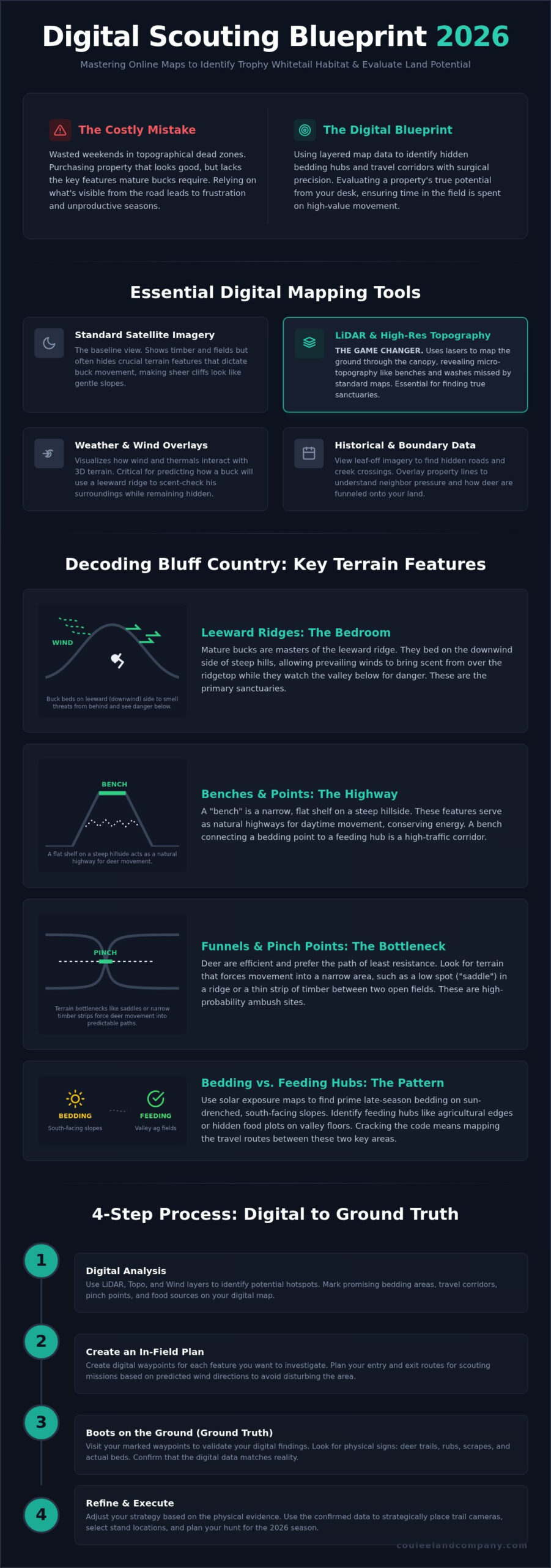
In 2026, a standard satellite view is just the beginning. While high-resolution imagery shows you the timber, it often hides the terrain features that actually dictate buck movement. Successful scouting for deer using online maps requires a layered approach where topographical data and LiDAR take center stage. These modern conservation technologies allow us to strip away the canopy and see the literal bones of the land.
Standard satellite maps can make a sheer cliff look like a gentle slope, leading to wasted miles on the ground. By utilizing 3D rendering, you can visualize elevation changes and steep coulees without the physical exhaustion of a blind hike. Additionally, historical imagery tools are vital. They let you view the property during leaf-off periods in late fall or early spring, revealing hidden creek crossings and old logging roads that are invisible under summer foliage. Integrating property boundary overlays is the final step, helping you identify neighbor pressure and the true sanctuary potential of the acreage.
LiDAR and High-Resolution Topography
LiDAR is the ultimate game changer for identifying trophy whitetail patterns. It uses laser pulses to map the ground surface, effectively seeing through the thickest cedar thickets and oak canopies. This reveals micro-topography, such as subtle benches or hidden washes, that standard 20-foot contour maps completely miss. For anyone evaluating hunting properties, this data is the difference between finding a true sanctuary and buying a dead zone.
Weather and Wind Overlays
Your digital map should also function as a laboratory for wind study. In the steep terrain of Western Wisconsin, thermal drift and wind current are everything. Mapping platforms now integrate live wind direction layers that interact with your 3D terrain model. This shows you exactly how a northwest wind will swirl in a specific coulee. It helps you predict how a mature buck will use the leeward side of a ridge to scent-check the valley below while keeping his eyes on the ridge top.
Decoding Bluff Country: Identifying Trophy Terrain Features
Buffalo County’s vertical landscape demands a specialized approach that flat-country hunters often overlook. When scouting for deer using online maps, you must look beyond the green and brown patches of satellite imagery. The real story is told in the shadows of the ridges. Mature bucks in this region are masters of the leeward ridge. They bed on the downwind side of steep hills, allowing the wind to bring scent from over the top while they watch the valley below for danger. Identifying these “quiet” zones on a topographical map is the first step in locating a trophy buck’s bedroom.
Points and benches act as the primary transition zones in Bluff Country. A bench is a narrow, flat shelf on a steep hillside that serves as a natural highway for daytime movement. When you find a bench that connects a bedding point to a feeding hub, you’ve found a high-traffic corridor. To truly understand these patterns, it helps to adopt a wide-angle strategy. Don’t just look at your 40-acre parcel; analyze the surrounding 500-acre neighborhood to see how deer are funneled onto your land from adjacent properties. Understanding these regional dynamics is why our land specialists focus so intently on the unique topography of Buffalo County properties.
Natural Funnels and Pinch Points
Look for bottlenecks where the terrain forces movement. A steep bluff meeting a river bend or a narrow strip of timber between two ridge-top fields creates a high-probability pinch point. Deer are incredibly efficient; they prefer the path of least resistance. They’ll avoid a 45-degree climb unless they’re pressured, so use your maps to locate “saddles” or low spots in a ridge line where they can cross with minimal effort.
Bedding vs. Feeding Hubs
Solar exposure maps are your best friend for late-season scouting. South-facing slopes receive the most direct sunlight, making them prime bedding areas when the Wisconsin winter sets in. Conversely, look for agricultural edges or hidden internal food plots on the valley floor. When you can map the relationship between a south-facing bedding slope and a nutrient-dense feeding hub, you’ve cracked the code for late-season whitetail patterns.
Strategic Execution: Transitioning from Digital Scouting to Property Mastery
Digital maps provide the framework, but the dirt provides the proof. Once you’ve finished scouting for deer using online maps, you must transition to “ground truth” validation. This phase is critical when reviewing hunting properties for sale. It’s about verifying that the digital bench you found actually holds the sign you expect. A digital map won’t show you the neighbor’s unshielded tractor path or a hidden public access point that creates unwanted pressure. Patterning the neighbors is just as vital as understanding your own acreage. Their land management directly impacts how deer utilize your sanctuary.
The 2026 E-Scouting Workflow
Efficiency is the hallmark of a professional land steward. Our team uses a disciplined workflow to ensure no time is wasted in the field:
- Step 1: Wide-Angle Analysis. We start with a 10,000-foot view of the regional habitat. This identifies how your parcel fits into the broader movement patterns of the local herd.
- Step 2: LiDAR Precision. We pinpoint three to five high-probability zones of interest. We look for those micro-benches and hidden funnels revealed by the latest remote sensing data.
- Step 3: Stealth Planning. We map out low-impact entry and exit routes. If you can’t get to your stand without blowing deer out of the coulee, the best spot on the map is worthless.
- Step 4: Ground Validation. We physically inspect the prioritized zones to confirm bedding sign, mast production, and active trail density.
Evaluating Land Value Through Scouting
A land specialist broker in Wisconsin does more than just list acreage. We use these digital tools to perform deep due diligence, ensuring a property’s price reflects its true trophy potential. The legendary reputation of Buffalo County deer hunting is built on specific terrain features that allow bucks to reach maturity. By linking terrain quality to digital data, we help buyers invest in land that produces year after year. This surgical approach to scouting for deer using online maps ensures your next property purchase is a legacy investment rather than a gamble.
Secure Your Legacy in Bluff Country
Success in Buffalo County isn’t left to chance. It’s built on a foundation of precise data and deep regional expertise. By leveraging advanced LiDAR layers and identifying the specific leeward ridges and benches that hold trophy whitetails, you transform from a casual hunter into a true land steward. Mastering the strategic process of scouting for deer using online maps is the ultimate competitive advantage in 2026. It ensures that every acre you evaluate and every stand you hang is backed by surgical terrain analysis. You’ve learned how to strip away the canopy and see the land’s true potential before ever leaving your home.
Our team at Coulee Land Company consists of authentic hunters and land managers who live and breathe Western Wisconsin whitetail stewardship. We don’t just sell property; we help you identify high-value landscapes that produce record-breaking wildlife year after year. Our deep expertise in Buffalo County ensures you find land that exceeds its market value and meets your hunting goals. Ready to find your own piece of Bluff Country? View our exclusive Wisconsin hunting land listings today.
The woods are waiting. With the right digital blueprint and a boots-on-the-ground approach, your dream of owning a premier hunting property is within reach. We look forward to seeing you in the coulees.
Frequently Asked Questions
What is the best free online map for deer scouting in 2026?
The Wisconsin DNR’s mapping tool is the premier free resource for scouting for deer using online maps in our region. It provides detailed public land boundaries and specialized habitat layers that generic maps lack. While it doesn’t offer the seamless interface of paid apps, it’s an excellent starting point for identifying broad landscape features and regional deer density statistics provided by state biologists.
How do I find bedding areas on a topographic map?
You find bedding areas on a topographic map by locating “points” where a ridge terminates and the contour lines widen. These wider spaces indicate a flat bench or a knob where a buck can bed with the wind at his back. In steep terrain, look for these features halfway down a ridge or on south-facing slopes that offer thermal advantages during the cold Wisconsin winters.
Can I use Google Earth for serious e-scouting in Wisconsin?
Google Earth remains a powerful tool for visualizing 3D terrain and historical land changes, but it lacks the specialized layers required for professional scouting. It doesn’t provide property boundary data or high-resolution LiDAR that reveals micro-topography under the canopy. We recommend using it alongside specialized hunting apps to get a complete picture of the landscape and neighbor pressure before committing to a hunt or property purchase.
What terrain features should I look for when buying hunting land in Buffalo County?
When evaluating Buffalo County properties, prioritize diverse elevation changes that create natural funnels and thermal hubs. You want to see a mix of high ridge-top agriculture and deep, secluded coulees that provide safe bedding. Look for properties with “interior” benches that allow for low-impact access. This ensures you can hunt the wind effectively without alerting the mature bucks that call these legendary bluffs home.