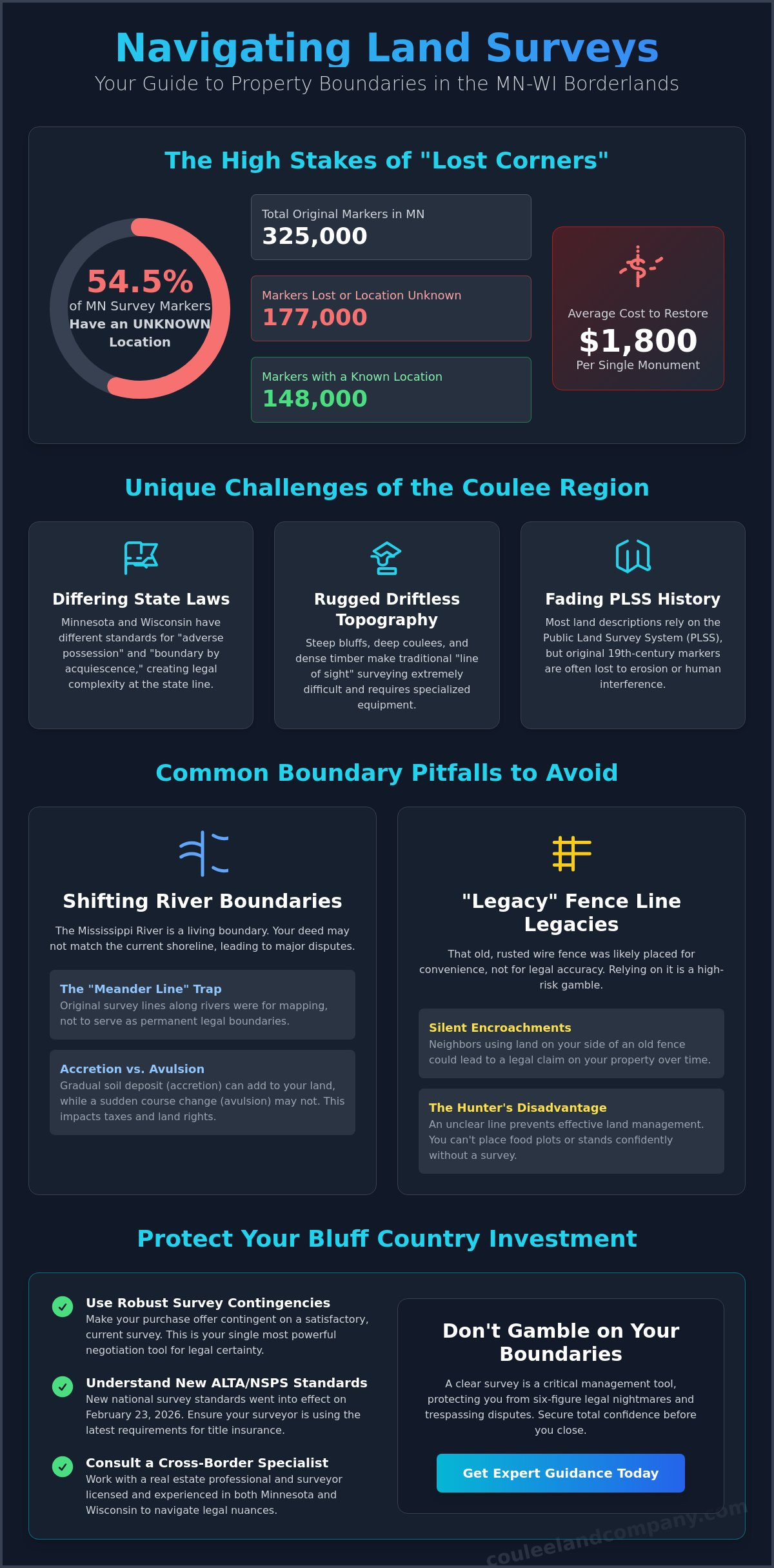
What if the difference between your dream hunting camp and a six-figure legal nightmare is a single rotted cedar post lost in a deep coulee? You’ve likely spent years scouting the perfect Bluff Country ridge, and you deserve to know exactly where your dirt ends and the neighbor’s begins. It’s a common fear for anyone eyeing high-value acreage, especially when you realize that only 148,000 of Minnesota’s 325,000 original survey markers have a known location. With the cost to find and restore a single monument averaging $1,800, the stakes for your property line are higher than ever.
We’re here to ensure you’re Navigating Land Surveys in MN-WI Borders: Common Issues and Solutions with total confidence. You’ll discover how to protect your investment from unreliable fence lines and shifting river boundaries while mastering the new ALTA/NSPS standards that went into effect on February 23, 2026. This article provides a clear roadmap for resolving disputes and securing legal certainty before you close on your next piece of trophy whitetail habitat. We’ll examine the impact of the latest 2026 licensing updates and the current $10 million funding efforts for remonumentation that affect every landowner in the Coulee Region.
Key Takeaways
- Understand how the rugged Driftless Area topography and differing state recording systems create unique challenges for identifying accurate borderland property markers.
- Gain the expert insight needed for Navigating Land Surveys in MN-WI Borders: Common Issues and Solutions. to safeguard your Bluff Country investment from hidden boundary disputes.
- Discover why “Meander Lines” along the Mississippi River mean your actual property boundary might not align with the current water’s edge.
- Identify why relying on old “legacy” fence lines leads to silent encroachments and how to resolve these disputes through formal out-of-court agreements.
- Master the use of robust survey contingencies in your purchase offers to ensure total legal certainty before you close on your next piece of hunting land.
Why Border Surveys in the MN-WI Coulee Region Are Uniquely Complex
The border between Minnesota and Wisconsin is more than just a line on a map; it’s a complex reconciliation of two distinct state recording systems and historical river markers that have shifted over nearly two centuries. When you’re Navigating Land Surveys in MN-WI Borders: Common Issues and Solutions., you’re dealing with the unique challenges of the Driftless Area. This rugged topography, defined by steep bluffs and deep coulees, makes traditional “line of sight” measurements incredibly difficult. Surveyors often find their paths blocked by limestone outcroppings or dense timber, requiring specialized equipment and expertise to establish a truly accurate boundary.
To better understand the historical weight of these boundary challenges, watch this helpful video regarding a long-standing border dispute in our region:
Most land descriptions in the region are rooted in the Public Land Survey System (PLSS). While this grid provided the foundation for westward expansion, many of the original 19th-century markers in areas like Buffalo County have been lost to erosion or human interference. As of May 2026, finding these “lost corners” is a high-stakes endeavor that requires a surveyor who understands the historical context of the land as much as the modern GPS coordinates.
The “Hunter’s Realtor” Perspective on Boundaries
For those investing in hunting properties, boundary integrity is a non-negotiable asset. Knowing your exact line is the difference between a peaceful morning in the stand and a frustrating trespassing dispute that ruins your season. We view a survey as a management tool. It allows you to strategically place bedding sanctuaries and food plots right up to the edge of your dirt without fear. If you don’t have a clear line, you can’t effectively manage the natural funnels that steer trophy whitetails through your acreage.
State-Line Nuances: Minnesota vs. Wisconsin Laws
Legal complexities multiply when a property straddles or sits near the state line. Wisconsin and Minnesota have different legal standards for “adverse possession” and “boundary by acquiescence.” While one state might require 20 years of continuous use to claim a boundary change, the other may have different statutory triggers. Navigating Land Surveys in MN-WI Borders: Common Issues and Solutions. requires a licensed specialist who can interpret these cross-border legalities to protect your investment from silent encroachments or legacy fence-line errors.
Common Survey Pitfalls: From Shifting Rivers to “Fence-Line” Legacies
One of the most deceptive traps for buyers along the Mississippi is the “Meander Line” trap. Many landowners assume their property line follows the current water’s edge, but these lines were originally drawn by 19th-century surveyors for mapping purposes, not as permanent boundaries. This confusion is a central challenge when Navigating Land Surveys in MN-WI Borders: Common Issues and Solutions. because the river is a living, moving entity. You need an expert who understands that your deed might say one thing while the current shoreline says another.
You must also account for the legal concepts of accretion and avulsion. Accretion is the gradual deposit of soil that can slowly increase your acreage, while avulsion refers to a sudden, violent shift in the river’s course. As of May 2026, these natural shifts continue to impact tax liabilities and wildlife habitat management across the region. A historical survey of the Wisconsin-Minnesota State Line reveals how the “Thalweg doctrine” (the middle of the main navigation channel) has historically governed these complex border disputes.
Legacy fence lines are another high-risk area in the backwoods. That rusted wire grown into a century-old oak tree was likely placed where it was easiest to dig, not where the legal line actually sits. These “fences of convenience” create silent encroachments that can stay hidden for generations until a modern survey is performed. If you’re looking at a Minnesota deed from 1950 that doesn’t align with a Wisconsin survey conducted in 2010, you’re likely facing a discrepancy that could cloud your title and disrupt your land management plans.
Riparian Rights and Waterfront Boundaries
Access to the Mississippi and its tributaries is a primary driver for high-value waterfront properties in the Coulee Region. You must determine if you own to the low-water mark or if the state holds a public trust over your shoreline. Understanding these riparian rights is essential for anyone looking to build docks or manage riverfront habitat.
Encroachments in the Backwoods
It’s common to find shared logging roads, hunting stands, or even small outbuildings that have drifted over the line. An encroachment is any physical intrusion across the surveyed boundary line that can cloud a title. Identifying these early is vital for maintaining good neighbor relations and ensuring a clean closing. If you’re preparing to list a property, consulting with a land specialist can help you address these issues before they stall a potential sale.
Navigating the Survey Process: Expert Solutions for Land Buyers and Sellers
Securing a piece of the Driftless Area requires more than just a handshake and a handshake-drawn map. When you’re Navigating Land Surveys in MN-WI Borders: Common Issues and Solutions., the most powerful tool in your arsenal is a robust survey contingency. This legal safeguard allows you to verify the acreage and boundary lines before your earnest money becomes non-refundable. If a survey reveals that a neighbor’s hunting cabin is sitting ten feet over the line, you have the leverage to demand a resolution or walk away from the deal entirely. It’s about protecting your capital and your peace of mind.
For those preparing to list their property, commissioning a pre-listing survey is a definitive power move. It eliminates the “fear of the unknown” for prospective buyers and can justify a higher asking price by proving the exact wildlife capabilities of the acreage. In the high-stakes world of Bluff Country real estate, certainty is a premium commodity. A standard residential agent might be comfortable with city plats, but they often struggle with the complexities of rugged hunting terrain. You need a broker who understands how to interpret topographic overlays and aerial data to identify natural funnels and bedding areas that a simple map might miss.
Steps to Resolve a Survey Dispute in 2026
- Hire a licensed MN-WI surveyor: Ensure they have experience with the specific challenges of the Coulee Region.
- Review historical deeds: Look for discrepancies between old descriptions and modern measurements.
- Consult with a land-specialist broker: Get an expert opinion on how the dispute affects the property’s market value.
- Negotiate a Boundary Line Agreement: This is the most efficient path to a resolution.
A Boundary Line Agreement is a recorded document that establishes a permanent, agreed-upon line regardless of historical errors. This practical, out-of-court solution allows neighbors to settle disputes over old fence lines without expensive litigation.
Preparing for Your Bluff Country Purchase
Modern land buying involves layering professional survey data with advanced GIS and LiDAR imagery. This “bird’s eye” view ensures you aren’t just buying a plot on a map, but a functional ecosystem with clear boundaries for land management. Navigating Land Surveys in MN-WI Borders: Common Issues and Solutions. is much simpler when you have the right team in your corner. For expert representation during the survey and closing phase, visit our Buyers page to see how we secure your investment.
Securing Your Legacy in the Bluff Country
Mastering the precise lines of your property is the final step in securing a legacy in the famed Driftless Area. We’ve explored how the rugged limestone bluffs of Buffalo County and the shifting meander lines of the Mississippi can complicate even the most straightforward land deal. Whether you’re reconciling a 1950s deed with a 2026 survey or identifying legacy fence-line errors, you need a partner who understands the dirt as well as the data. Navigating Land Surveys in MN-WI Borders: Common Issues and Solutions. is a manageable process when you apply proactive strategies like survey contingencies and Boundary Line Agreements.
As Wisconsin’s Land & Property Sales Specialists, we bring an expert hunter’s eye to every transaction. Our team is endorsed by top leaders in the outdoor television world, and we possess deep expertise in the Mississippi River Bluff Country. We don’t just sell acreage; we protect the integrity of your hunting sanctuaries. Talk to a Coulee Land Specialist about your property boundaries today. Your peace of mind on the ridge starts with a clear line and a trusted guide.
Frequently Asked Questions
What is the average cost of a land survey in the MN-WI border region?
The cost of a land survey is determined by the complexity of your terrain and the presence of existing markers. For example, the estimated cost to find and restore a single Public Land Survey System monument in Minnesota is approximately $1,800 as of May 2024. Total project fees will fluctuate based on whether you require a basic boundary stake-out or a comprehensive ALTA/NSPS Land Title Survey for a high-value property.
Does a fence line automatically become the property line after a certain number of years?
No, a fence line does not automatically override your legal deed just because it has been in place for decades. While Wisconsin law generally recognizes a 20-year period for adverse possession claims, the legal burden of proof is exceptionally high. You must demonstrate that the use of the land was open, notorious, and hostile. It’s much more efficient to resolve these discrepancies through a formal Boundary Line Agreement rather than litigation.
What happens if a survey shows my neighbor’s hunting stand is on my land?
If a survey confirms a neighbor’s hunting stand is on your side of the line, you are facing a physical encroachment. You should address this intrusion immediately to prevent any future claims of adverse possession and to keep your title clear. This is a critical step when Navigating Land Surveys in MN-WI Borders: Common Issues and Solutions. because it protects the integrity of your sanctuary. A land specialist can help facilitate a respectful conversation to ensure the stand is moved.
Can a river shift actually change my property boundaries in Wisconsin or Minnesota?
A river shift can legally change your property boundaries through the natural processes of accretion and avulsion. Accretion is the gradual buildup of soil that can slowly increase your total acreage over time. However, avulsion refers to a sudden, violent change in the river’s channel, which typically does not move the established legal boundary line. Understanding these riparian rights is essential when Navigating Land Surveys in MN-WI Borders: Common Issues and Solutions. along the Mississippi River.