You can spend 40 hours a week on the water and still go home empty-handed if you don’t respect the 700 miles of current that define the upper Mississippi. Most anglers understand that the river is a fickle beast; one day the wing dams are loaded with sauger, and the next, a three-inch rise in water levels sends the entire school into hiding. It’s frustrating to battle unpredictable currents and heavy barge traffic only to miss the bite by a few hundred yards. At Coulee Land Company, we know this land and its waters because we live here, and we’ve seen how the right knowledge turns a grueling day into a legendary haul.
We’re going to provide the exact technical tactics and seasonal maps required for fishing the Mississippi River Alma with confidence. You’ll master the specific migration patterns of walleye through Pools 4 and 5 while learning to navigate hazardous wing dams that claim dozens of lower units every season. This guide breaks down the transition zones between the locks, offers professional safety protocols, and explores why this rugged stretch of Buffalo County is the premier destination for those looking to secure a permanent cabin or riverfront property.
Key Takeaways
- Identify how Lock and Dam #4 creates a biological bottleneck that concentrates trophy walleye and sauger, making fishing the Mississippi River Alma a premier experience.
- Master the seasonal shift from the aggressive spring pre-spawn run to the technical summer patterns found along the main channel and deep wing dams.
- Compare the best access points for every style of angler, from the mobility of boat fishing to the unique community atmosphere of the Alma Fishing Float.
- Learn the expert “three-step approach” to reading river currents, allowing you to effectively fish the face, top, and scour hole of any wing dam.
- Understand the unique synergy between world-class river fishing and the legendary trophy whitetail hunting that defines the Bluff Country lifestyle.
Understanding the Waters: An Overview of Pool 4 and Pool 5 Near Alma
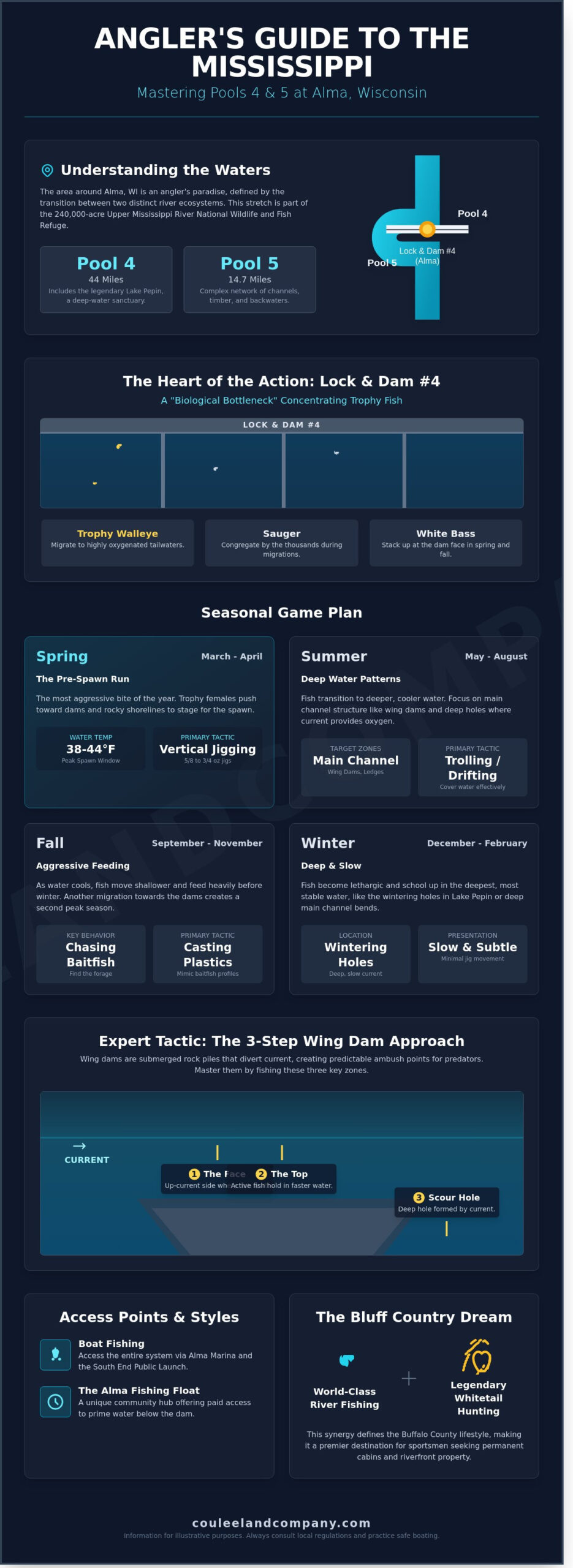
Alma represents the ultimate intersection of rugged terrain and productive water. This historic river town is squeezed between the massive limestone bluffs and the flowing current of the Mississippi River. Fishing the Mississippi River Alma is a bucket-list experience for serious anglers because of the unique geography found within the reach of a single boat launch. The town sits at the transition point between two distinct river ecosystems: Pool 4 and Pool 5. These pools offer a combined 58.7 miles of navigable water, each providing a different challenge and reward for those seeking trophy class fish.
The Upper Mississippi River National Wildlife and Fish Refuge encompasses this entire stretch, protecting 240,000 acres of critical habitat. Pool 4 is a sprawling 44-mile stretch that includes the legendary Lake Pepin, where deep-water sanctuaries hold massive schools of walleye. In contrast, Pool 5 begins at the Alma dam and runs 14.7 miles downstream. It features a complex network of side channels, flooded timber, and backwater sloughs. This diversity makes Alma the undisputed epicenter of Western Wisconsin’s Bluff Country outdoor lifestyle, attracting thousands of sportsmen who appreciate the area’s rich biological productivity.
Lock and Dam #4 serves as a biological bottleneck. Since its completion in 1935, this structure has dictated the movement of fish throughout the region. Migrating species are funneled into the tailwaters, creating one of the highest concentrations of game fish in the Midwest. Whether you are looking for a weekend retreat or considering a permanent move to the region, understanding these waters is the first step in mastering the local lifestyle.
The Role of Lock and Dam #4
The dam creates a highly oxygenated environment that acts as a magnet for trophy walleye and sauger. Massive volumes of water pouring over the spillways create current seams and eddies where predators wait to ambush baitfish. During the spring and fall migrations, sauger and white bass congregate by the thousands at the dam face. Anglers who learn to read the turbulent water can find consistent success by targeting the specific lines where fast and slow water meet. These tailwaters remain productive even during the heat of summer because the constant movement keeps water temperatures lower than the surrounding backwaters.
Navigating the Buffalo County Waterfront
The scenic shoreline of Buffalo County provides a world-class backdrop for recreation. This region is famous for its hunting prestige, but the waterfront is equally impressive. Public access is convenient, with the Alma Marina and the south end public boat launch serving as primary entry points for the fleet. These facilities provide reliable access to both the main channel and the hidden sloughs of Pool 5. The steep bluffs protect the river from heavy winds, which allows for safer navigation compared to the open waters of Lake Pepin. This accessibility is a primary reason why land in this corridor remains highly coveted by outdoor enthusiasts.
Seasonal Patterns: When to Target Mississippi River Giants
Success on the water requires more than just a lucky lure; it demands an intimate understanding of the river’s biological clock. Fishing the Mississippi River Alma provides a year-round masterclass in seasonal migration and habitat selection. The river is a living system that shifts its priorities as the Wisconsin landscape transitions from the frozen silence of January to the humid peaks of July. Local experts know that the “giants” don’t disappear; they simply relocate based on water temperature, oxygen levels, and forage availability.
The annual cycle begins with the spring run in March and April. This is when the pre-spawn walleye push toward the dams and rocky shorelines. You’ll find these fish stacked in eddies and behind current breaks, waiting for the signal to move onto the gravel bars. As the ice clears, the water remains a frigid 34 to 36 degrees, requiring a slow, methodical approach to trigger a strike from a trophy female.
Spring Walleye Tactics
Vertical jigging is the gold standard when the current picks up in April. You’ll need heavy lead, often 5/8 to 3/4 ounce jigs, to keep your plastic tail pinned to the bottom in high-flow conditions. Watch your electronics for water temperatures reaching the 38°F to 44°F range. This window marks the peak of spawning activity. If the bite is lethargic, switch to a purple or orange hair jig tipped with a fathead minnow to provide the subtle profile and scent needed to convince a pressured fish.
Summer and Fall Transitions
When the July heat settles over Buffalo County, the walleye and smallmouth bass move toward the main channel. Trolling deep-diving crankbaits along the edges of the shipping lanes becomes the primary strategy for covering water. You must target the deep wing dams where the current forces oxygenated water over the rocks. By September, falling water levels begin to concentrate fish into the deepest holes and scour pools. This period offers some of the most consistent action of the year for those who can read the changing bathymetry.
The autumn transition is also the perfect time to pull the boat into a quiet slough and look upward. Many anglers use these October trips to combine a morning of sauger fishing with an afternoon of scouting for trophy whitetails along the river bluffs. The intersection of world-class fishing and the legendary hunting of the Coulee Region is what makes this area a premier destination for serious outdoorsmen.
Winter doesn’t end the pursuit; it merely changes the terrain. As the main channel becomes treacherous with floating ice, the backwaters and sloughs transform into a frozen playground. According to data and habitat maps provided by the U.S. Fish & Wildlife Service, these sheltered areas provide critical thermal cover for panfish and northern pike. Target the 4 to 8 foot depths near submerged timber. Large bluegills and aggressive pike are common in the “dead” water where the current is non-existent. Fishing the Mississippi River Alma during the winter requires caution and a solid understanding of ice thickness, but the rewards for those who brave the cold are often the most memorable catches of the season.
The Alma Fishing Experience: Boats, Floats, and Shorelines
Fishing the Mississippi River Alma provides a diverse range of opportunities that cater to every tactical preference. Whether you’re operating a high-performance fiberglass bass boat or carrying a single rod to the city breakwater, the river offers productive water for those who understand its seasonal rhythms. The choice between boat, float, or shore fishing often dictates your success rate based on the 24-hour water level fluctuations and current velocity. Mobile anglers in boats can scout the vast networks of wing dams and backwater sloughs, while those on the Alma Fishing Float benefit from a stationary position in the most oxygenated, bait-rich water on the river.
The Legendary Alma Fishing Float
The Alma Fishing Float has been a staple of the local outdoor culture since 1948. It remains a “bucket list” destination for Midwest anglers because it provides access to the turbulent, fish-rich waters directly below the dam that are otherwise dangerous for small craft. For a $20 round-trip fee, a shuttle boat transports you from the marina to this stable, floating platform. You should bring two rods, a cooler for your catch, and enough lead to hold bottom in heavy current.
Success on the float requires a mix of patience and technical skill. Dead-sticking a fathead minnow on a three-way rig is the primary method for targeting walleye and sauger. Active jigging with 1/2-ounce or 5/8-ounce hair jigs becomes necessary when the current exceeds 2.5 knots. The social culture here is unmatched. It’s a place where seasoned veterans share tips with novices, and families often spend 10-hour days enjoying the communal atmosphere of the Bluff Country’s finest fishing hole.
Mastering Boat Positioning in Current
Boat fishing offers the ultimate mobility to hunt for trophy class fish, but it demands specialized equipment. To stay on “the spot” in the main channel, a 24-volt or 36-volt trolling motor with at least 80 pounds of thrust is a non-negotiable requirement. The river current frequently runs at 3 to 5 miles per hour, which can quickly drain underpowered batteries. Using GPS anchoring, commonly known as Spot-Lock, allows you to hover with precision over submerged rock piles or current breaks without the physical labor of tossing a heavy river anchor.
Safety is the primary concern when fishing the Mississippi River Alma from a boat. The U.S. Army Corps of Engineers – Lock & Dam 4 manages the constant flow of commercial barge traffic through this corridor. These 1,200-foot towboats cannot stop or turn quickly. You must maintain a distance of at least 150 feet from the dam gates and stay well clear of the navigation channel when a tow is approaching. Precision positioning near the wing dams is rewarding, but one mechanical failure can put a boat in a dangerous situation against the rocks.
Shore Fishing and Accessibility
Shore fishing remains a powerful option for those who prefer a simplified approach. The Alma city breakwater and local parks provide stable footing for targeting panfish and seasonal runs of white bass. During the 2023 spring season, shore anglers reported consistent limits of yellow perch using simple slip-bobber rigs set at 8 to 12 feet.
- Pros of Boat Fishing: High mobility, access to hidden sloughs, and ability to track moving schools.
- Pros of the Alma Float: Low cost, high safety, and constant proximity to the dam’s tailwaters.
- Pros of Shore Fishing: Zero equipment overhead and immediate access to local amenities.
The river doesn’t care about your gear. It rewards knowledge of the current. Each method has its day depending on the weather. High winds often make boat control impossible, driving smart anglers to the protected side of the fishing float or the leeward shorelines.
Technical River Tactics: Wing Dams, Barges, and Navigation
Success when Fishing the Mississippi River Alma depends on your ability to decode the complex hydraulics created by wing dams. These rock dikes, built by the Army Corps of Engineers, extend from the shoreline toward the main channel to constrict flow and maintain the 9-foot navigation depth. To fish them effectively, you must learn to read the water’s surface. Look for the “boil,” which is the turbulent, bubbling water rising directly over the submerged rocks. Just downstream of this disturbance, you’ll find the “slick,” a patch of smooth water where the current has been diverted. Identifying these markers allows you to visualize the structure without relying solely on electronics.
A disciplined 3-step approach is the gold standard for dissecting a wing dam. Start by targeting the “face,” or the upstream side of the rocks. This is the high-pressure zone where active predators like walleye and smallmouth bass wait for baitfish to be swept toward them. Next, probe the “top” of the dam. If the river stage allows for at least 3 feet of clearance, fish will often move onto the rocks during low-light periods. Finally, focus on the “scour hole.” This is the deep pocket carved out by the current at the very tip of the wing dam. It’s a prime location for trophy fish looking for a break from the heavy main-channel current.
Fishing the Wing Dams
When you’re targeting smallmouth, casting shallow-running crankbaits or 4-inch swimbaits across the rocks is a proven tactic. Position your boat roughly 40 feet upstream and use your trolling motor or a “Spot-Lock” feature to hold steady. Pitch 1/4-ounce jigs directly into the face of the dam, letting the current bounce the lure along the transition where the river floor meets the rock base. You must remain vigilant about your depth. Submerged rocks are unforgiving. Striking a wing dam at even 10 miles per hour can result in a $4,200 lower unit repair or a damaged hull. Always approach these structures from the channel side to minimize risk.
Mississippi River Safety and Etiquette
Safety on the Mississippi isn’t optional; it’s a requirement for survival. Before you leave the dock, check the USGS Gauge 05378500 at Alma. If the river is rising rapidly or flow rates exceed 65,000 cubic feet per second, the current becomes significantly more dangerous. You also need to respect the “Tonnage Rule.” A standard 15-barge tow can weigh more than 22,000 tons. These massive vessels can’t stop quickly and have limited visibility. Never attempt to cross the bow of a moving tow within 1,000 yards. If you’re unsure of a pilot’s path, use a VHF radio on Channel 13 to announce your position and intentions.
- Stay in the Channel: Follow the buoy system. Green “can” buoys and red “nun” buoys mark the 9-foot navigation channel.
- Respect the Buffer: Give other anglers at least 150 yards of space. Crowding a wing dam is a quick way to ruin the bite for everyone.
- Monitor the Wake: Large vessels create significant swells that can swamp a small fishing boat anchored near the rocks.
Living the Bluff Country Dream: Beyond the Riverbank
For many anglers, the experience of Fishing the Mississippi River Alma transforms from a seasonal hobby into a lifelong obsession. You spend years trailering a boat to the public landing, checking the river gauges, and scouting the shifting backwaters of Pool 4. Eventually, the desire for a permanent base of operations takes over. Owning waterfront property in Buffalo County isn’t just a real estate transaction; it’s a strategic move for the dedicated outdoorsman who values immediate access to the water.
The geography of the Coulee Region is unlike any other landscape in the Midwest. Steep limestone bluffs drop directly into the fertile river valley, creating a rare synergy where your morning can be spent landing walleyes and your afternoon can be spent glassing for trophy whitetails on the same parcel. Buffalo County has led the nation in Boone and Crockett record book entries for decades, boasting over 1,300 registered trophies. This density of elite wildlife makes every acre in this region a high-value retreat that serves dual purposes for hunters and fishermen alike.
Investing in land here is a long-term play. The “Coulee Region” geography creates secluded pockets of land that are naturally protected from heavy traffic. These properties offer a level of privacy that’s becoming increasingly rare. Because the topography is so vertical, the acreage often feels much larger than the survey indicates, providing vast recreational opportunities within a compact footprint. This finite supply of land ensures that Buffalo County remains a premier destination for those looking to park their capital in a tangible, enjoyable asset.
From Weekend Trips to Waterfront Ownership
Owning a private dock or a cabin with direct river access eliminates the friction of public landings and crowded parking lots. You gain the ability to launch at dawn without a queue, reacting instantly to favorable weather patterns or hatch reports. Coulee Land Company specializes in helping outdoorsmen find these “Signature Properties” that offer more than just a view. We look for land with established wildlife corridors and secure, year-round access points. The Bluff Country lifestyle is the ultimate fusion of elite river angling and world-class whitetail hunting.
Expert Guidance for Land Buyers
Buying riverfront land in Western Wisconsin requires more than a standard real estate license. It demands a specialist who understands the nuances of the terrain and the specific legalities of the river valley. Working with land specialists like Mike Law or Bryan Lemke ensures you don’t overlook critical details that could impact your investment. We analyze 100-year floodplain maps, evaluate riparian rights, and navigate local zoning ordinances that vary significantly between townships like Alma and Nelson.
When you spend enough time Fishing the Mississippi River Alma, you realize the river is only half the story. The land provides the legacy and the base camp for every adventure. Understanding the wildlife capabilities of a property is just as important as knowing where the wing dams are located. We treat every land search as a mission to find a property that will perform for generations. Your best days on the river start with owning the land you love.
Claim Your Stake in the Mississippi River Valley
Mastering the wing dams of Pool 4 and navigating the complex currents of Pool 5 requires both technical skill and local knowledge. You’ve learned how seasonal shifts dictate the movement of trophy walleye and how to leverage the river’s unique structure for success. Fishing the Mississippi River Alma isn’t just a weekend hobby; it’s a gateway to a lifestyle defined by the rugged beauty of Buffalo County. This region dominates the whitetail entries in the Boone and Crockett Record Book, making it the ultimate destination for the dedicated outdoorsman who demands the best from their land.
At Coulee Land Company, we bring over 50 years of combined land brokerage expertise to help you secure your own piece of this legendary landscape. Our team’s work is endorsed by outdoor television professionals who trust our deep understanding of wildlife capabilities and land management. We don’t just sell property; we serve as Wisconsin’s Land and Property Sales Specialists. Find your dream waterfront property in Bluff Country today! The river is calling, and your perfect basecamp is waiting.
Frequently Asked Questions About Fishing in Alma
Do I need a Wisconsin or Minnesota fishing license to fish the Mississippi River in Alma?
You can use either a valid Wisconsin or Minnesota fishing license to fish the Mississippi River in Alma thanks to the reciprocal boundary water agreement. This rule applies to the main channel and all connected backwaters between the railroad tracks on the Wisconsin and Minnesota shores. If you decide to fish a tributary or inland lake beyond those tracks, you’ll need the specific license for that state. This 1940s agreement makes it easy for anglers to navigate the diverse waters of the Coulee Region without worrying about crossing state lines.
What is the best time of year to catch walleye in Alma, WI?
The premier window for walleye begins in late October and peaks during the spring pre-spawn run in March and April. During these 4 months, trophy fish congregate below Lock and Dam #4 to feed in the oxygenated tailwaters before the season closes on April 15. Fishing the Mississippi River Alma during this stretch offers your best 80% chance at a double-digit walleye. While summer produces fish, the cooling water temperatures of autumn trigger a massive movement of fish toward the deep wintering holes near the dam.
Is the Alma Fishing Float open year-round?
No, the Alma Fishing Float operates seasonally, typically opening in mid-March and closing in late November based on river ice conditions. The float is usually removed from the river before the first hard freeze in December to prevent damage from moving ice floes. For the 2024 season, the opening date depends entirely on the spring thaw and the safety of the shuttle route. It’s a legendary destination in Buffalo County that provides shore-bound anglers access to deep-water current breaks they couldn’t otherwise reach.
Can I safely fish the Mississippi River in a 14-foot aluminum boat?
You can safely fish a 14-foot aluminum boat in the protected backwaters and sloughs, but the main channel requires extreme caution. A 3-foot wake from a passing commercial barge can easily swamp a small craft with low gunwales. Always monitor the USGS gauge at Alma; if the river stage exceeds 10 feet, small boats should avoid the main current entirely. It’s vital to stay 500 feet away from moving tows to ensure you aren’t pulled into their powerful prop wash.
What are the most common lures for Mississippi River sauger?
Vertical jigging is the gold standard for sauger, using 3/8 to 5/8 ounce jigs tipped with fathead minnows or 3-inch plastic paddletails. Sauger often hold in 15 to 25 feet of water along the channel breaks where they can avoid the strongest current. High-visibility colors like chartreuse, orange, and bright white are 90% more effective in the stained water conditions common to this stretch. Many locals also swear by three-way rigs with a floating jig head to keep the bait just inches above the snag-filled bottom.
Where are the best public boat launches in Alma?
The Alma Marina on Main Street provides the most reliable access with a 3-lane concrete ramp and parking for over 100 vehicles. Another excellent option is Breckow’s Landing, located 2 miles north of town, which offers a more direct route to the tailwaters of Lock and Dam #4. Both sites require a daily launch fee, usually around $5 to $10, which supports local harbor maintenance. These launches are the gateways to the finest fishing the Mississippi River Alma has to offer for both casual and professional anglers.
Are there specific regulations for the no-fishing zone near Lock and Dam #4?
Federal law prohibits fishing or boating within 150 feet of the Lock and Dam #4 structure to ensure public safety and dam security. This restricted zone is clearly marked with large yellow signs and buoys maintained by the U.S. Army Corps of Engineers. Violating this boundary can result in a $250 fine and immediate removal from the area by local or federal authorities. It’s essential to respect these markers, as the turbulent water near the gates creates dangerous undertows that can capsize even large vessels.
What is the Alma Float and how do I get to it?
The Alma Float is a massive, stationary fishing platform anchored in the high-action tailwaters directly below the dam. To reach it, you must board a shuttle boat at the designated dock on the Alma riverfront, which runs every 30 minutes during peak daylight hours. This unique facility allows anglers without a boat to experience world-class fishing for a daily fee of approximately $20. It’s a staple of the local outdoor culture, offering amenities like a snack bar and restrooms right in the middle of the river.