In the rugged verticality of Western Wisconsin’s Bluff Country, a ground-level view often tells less than half the story. You’ve likely spent a long Saturday hiking through dense timber only to realize the layout doesn’t match your vision. It’s frustrating to waste time on properties that look different in person. We understand that your time is valuable and your standards for hunting land are high. That’s why we’ve mastered Drone Views of Western WI Land: How We Showcase Properties Like No One Else.
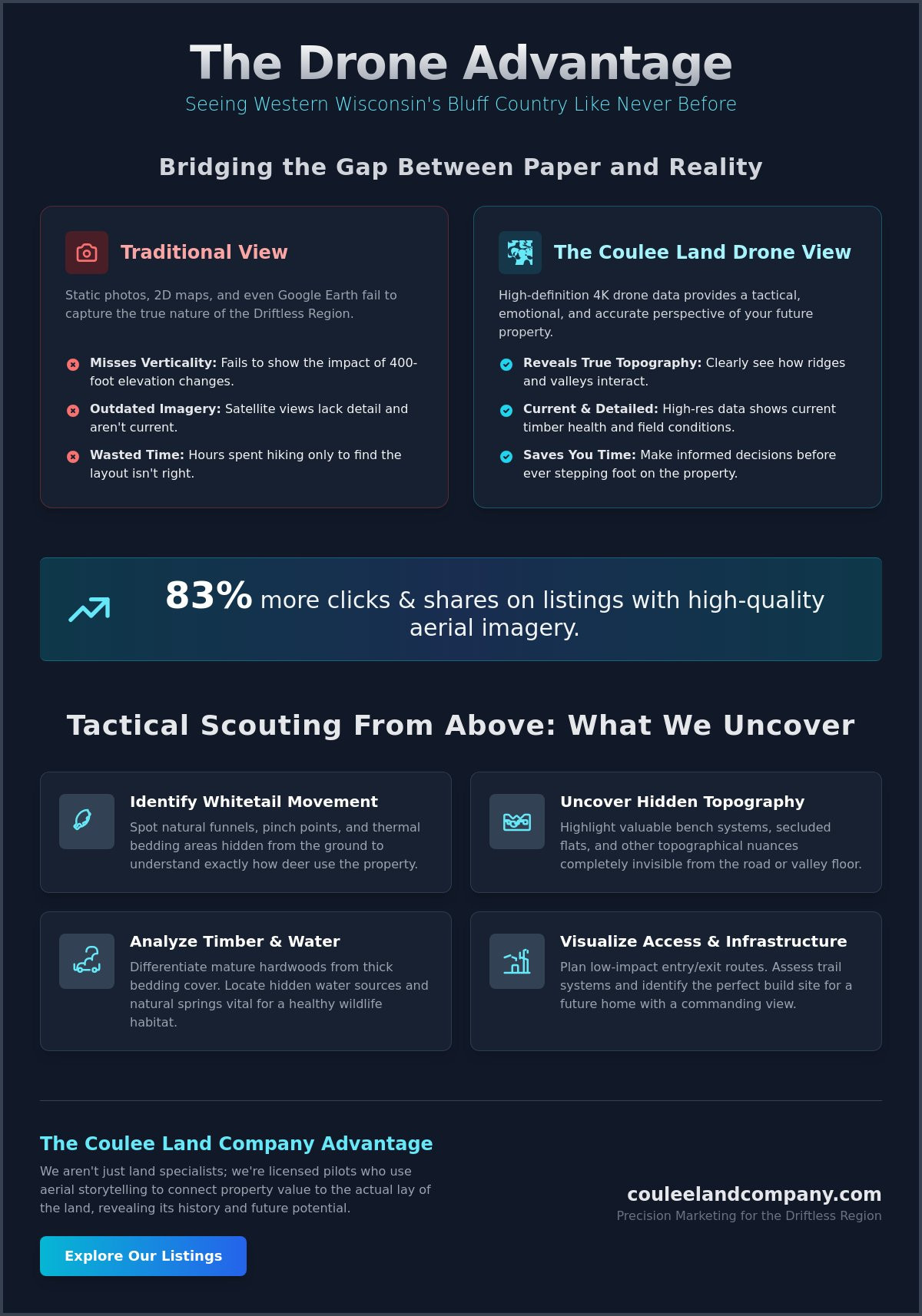
Research shows that listings with high-quality aerial imagery can increase clicks and shares by up to 83 percent. For our team, it’s about more than just a marketing edge. We use aerial storytelling to reveal the hidden potential of the Driftless Region. This approach shows you the exact tactical value of ridge-top views and valley funnels before you ever step foot on the dirt. You’ll gain a deep understanding of timber layouts and features like natural springs that ground-level photos simply miss. This article explores our specialized scouting process and explains how our expert perspective helps you move faster in a competitive market.
Key Takeaways
- Understand why traditional photography fails to capture the 400-foot elevation shifts of the Driftless Region and how aerial views bridge that gap.
- Learn to identify critical whitetail movement patterns, including natural funnels and thermal bedding areas, from a bird’s-eye perspective.
- Discover the specialized process behind Drone Views of Western WI Land: How We Showcase Properties Like No One Else. to ensure every acre is represented with expert precision.
- See how partnering with land specialists who are also licensed pilots ensures that the most valuable hunting and agricultural features are never overlooked.
- Explore the “Legacy View” concept, a unique storytelling approach that highlights the history and future potential of your property to attract high-value buyers.
Beyond Static Photos: Why Western WI Topography Demands Aerial Storytelling
The Driftless Area of Western Wisconsin is a landscape defined by its verticality. Traditional 2D maps and static photography fail to convey the reality of 400-foot elevation changes that characterize this region. When you look at a standard plat map, you see flat lines; when you look at the actual land, you see daunting ridges and deep coulees. This is why we utilize the unmanned aerial vehicle (UAV) to bridge the gap between paper and reality. Our Drone Views of Western WI Land: How We Showcase Properties Like No One Else. provide a perspective that ground-level scouting simply cannot match.
Many buyers rely on Google Earth to research properties, but satellite imagery is often outdated and lacks the resolution needed to judge current timber health or field conditions. Our high-definition 4K drone data captures the land in its current state, showing you exactly how ridges and valleys interact. There’s a powerful emotional connection when you see a sunrise breaking over your own forested ridge from 300 feet up. It transforms a piece of real estate into a personal legacy and a tangible dream.
The Vertical Advantage in Bluff Country
In high-demand regions like Buffalo County, the value of a property often lies in its “hidden” features. We use drones to highlight bench systems and secluded flats that are completely invisible from the road or lower valley. These topographical nuances are the primary travel corridors for trophy whitetails and determine the true agricultural potential of the acreage. By revealing these layers, we connect property value to the actual lay of the land. Our goal is to provide a tactical understanding that ensures you aren’t just buying a plot of dirt; you’re investing in a specific landscape designed by nature.
Tactical Scouting from Above: What Drone Views Reveal to Savvy Buyers
For a serious land manager, the view from the ground is just the beginning. True tactical scouting requires a bird’s-eye view to identify the natural funnels and pinch points that dictate trophy whitetail movement across a property. Our approach to Drone Views of Western WI Land: How We Showcase Properties Like No One Else. provides this exact level of detail. By observing the land from above, you can spot thermal cover and bedding areas that remain hidden during a standard walk-through. It’s also the most effective way to evaluate neighbor pressure. Seeing a neighbor’s stand placement or food plot locations allows you to strategically plan your own layout to ensure maximum privacy and hunting success.
The National Association of REALTORS® reports that high-quality visuals are essential for modern buyers, but for land investors, these images serve a functional purpose. You can map out future food plots and potential stand locations before you even schedule a site visit. This level of preparation saves time and builds confidence in a property’s long-term potential. If you’re ready to see how this data changes your search, you can browse our current listings to see these tactics in action.
Reading the Timber and Water
High-resolution aerials allow us to differentiate between mature hardwood ridges and the thick, nasty brush that whitetails prefer for bedding. We can also locate hidden water sources and natural springs that are vital for high-quality hunting properties. Aerial scouting serves as the primary filter for modern land investors in 2026, allowing them to verify property claims with visual proof. Identifying these features from the air ensures that you focus your energy on the most productive acres.
Visualizing Access and Infrastructure
Low-impact entry and exit routes are the difference between a successful season and a burned-out property. We use drone footage to plan routes that keep the wind in your favor and your presence undetected. Beyond hunting, this technology is invaluable for assessing existing trail systems and identifying the best building sites for country homes. You’ll see exactly how a driveway might wind through the timber or where a walk-out basement could overlook a valley.
The Coulee Land Advantage: Precision Marketing for the Driftless Region
Marketing a high-value bluff property requires more than a standard real estate lens. We employ land specialists who are also expert drone pilots because they understand the specific features that drive value in the Driftless Region. A generic photographer might capture a nice view, but our team identifies the structural components of a world-class hunting tract, such as corridor connectivity and ridge-top access. They see what others miss. We operate strictly under Federal Aviation Administration (FAA) rules to ensure professional, legal, and high-quality results for every client. This precision is the foundation of Drone Views of Western WI Land: How We Showcase Properties Like No One Else.
Our ‘Legacy View’ approach packages this aerial footage to tell a comprehensive story of the land. We don’t just show the current state of the timber; we highlight the property’s history and its future potential for meticulous land stewardship. This perspective is vital for out-of-state buyers who often purchase with absolute confidence from hundreds of miles away based on our immersive tours. By integrating this rich aerial data into our proven methods for selling hunting land in Wisconsin, we maximize your ROI and attract serious investors who value the land’s true character. It’s a marketing edge that turns a listing into a destination.
How We Showcase Your Property to the World
We leverage high-profile industry endorsements and media personalities to give your property unmatched visibility in the outdoor community. Our pilots prioritize ‘golden hour’ shoots, capturing the dramatic shadows and rich colors that define Western Wisconsin’s natural beauty at dawn and dusk. You can see how our agents, like Mike Law, use this technology to bridge the gap between sportsmen and real estate professionals. This authentic, hands-on approach ensures that your property’s story is told by those who truly know and respect the land.
Master the Terrain of the Driftless Region
Owning property in Western Wisconsin is about more than just acreage; it’s about understanding the complex relationship between the ridges and valleys of the Driftless Area. We’ve shown how aerial storytelling goes beyond simple photography to provide a tactical advantage for both buyers and sellers. By revealing hidden bench systems and identifying critical whitetail movement patterns, our Drone Views of Western WI Land: How We Showcase Properties Like No One Else. ensure no detail is left to chance. Our team is deeply rooted in this landscape, specializing in the unique topography of Buffalo County and the surrounding bluffs.
Our expertise in Buffalo County Wisconsin deer hunting and land management is why we’re the trusted choice for serious outdoor enthusiasts. Endorsed by high-profile industry leaders, we bring a level of authority and diligence that’s unmatched in the region. Whether you’re looking to sell a legacy tract or find your dream hunting ground, we have the tools and the passion to make it happen. Ready to see your land from a new perspective? Contact our specialists today. We look forward to helping you write the next chapter of your land ownership story.
Frequently Asked Questions
Can drone footage accurately show property boundaries in Western Wisconsin?
Drone footage provides a powerful visual reference for property boundaries by overlaying GIS data and plat maps onto high-resolution video. While this doesn’t replace a legal land survey, it allows you to see exactly where a property line falls in relation to physical landmarks like ridge tops, fence lines, or creek beds. This visual clarity is a core part of Drone Views of Western WI Land: How We Showcase Properties Like No One Else., giving buyers a clear sense of the land’s actual footprint.
Do I need drone footage to sell my hunting land in 2026?
Aerial footage is essentially mandatory for any seller who wants to remain competitive in the 2026 real estate market. Verified statistics show that properties featuring aerial images can sell up to 68 percent faster than listings that rely solely on ground-level photos. In the vertical terrain of the Driftless Area, a drone is the only tool capable of proving the tactical value of your ridge systems and hidden valleys to a global audience of serious investors.
How does drone scouting differ from using hunting apps like OnX or HuntStand?
Drones offer real-time, high-definition data that hunting apps simply can’t match. While apps are excellent for general navigation, their satellite imagery is often several years old and lacks the resolution to see current timber health or fresh deer bedding areas. A drone flight captures the land exactly as it looks today. This level of current detail makes Drone Views of Western WI Land: How We Showcase Properties Like No One Else. the superior choice for modern tactical planning.
Is drone footage useful for evaluating agricultural land or just hunting land?
Aerial data is incredibly valuable for evaluating agricultural land because it reveals drainage patterns and soil erosion that are invisible from the road. It allows farmers and investors to assess crop uniformity and identify potential equipment access issues across large tillable tracts. Whether you’re looking at productive soil or thick timber, aerial views provide the comprehensive overview needed for a sound investment and long-term land stewardship.