A static ground-level photo of a wooded ridge isn’t just outdated; it’s a financial liability that hides your property’s true value from the world’s most serious buyers. You understand that selling a premier tract in Wisconsin’s Bluff Country requires more than a few snapshots of a gate or a gravel road. This is why professional drone photography for real estate land listing has become the non-negotiable standard for 2026. Serious land investors and trophy hunters need to see the pinch points, the hidden springs, and the exact way the thermal currents move across your ridges before they’ll even book a showing.
We agree that the traditional way of listing land often fails to convey the sheer scale and wildlife potential of a high-end property. This guide promises to show you how specialized aerial imagery transforms raw acreage into a high-value narrative that captures the attention of out-of-state buyers ready to pay a premium. We’ll cover everything from mapping precise property boundaries to showcasing the “Boone and Crockett” potential of your timber, ensuring your land stands out in a crowded market.
Key Takeaways
- Understand why standard ground-level photography fails to communicate the true scale and connectivity of recreational parcels to serious land buyers.
- Learn how specialized drone photography for real estate land listing uses boundary overlays to clearly define property lines against the rugged landscape.
- Discover the essential aerial shots that highlight topographical features like ridges and thermal cover, which are critical for showcasing trophy whitetail potential.
- Navigate the legal requirements of commercial drone use and learn why a land specialist’s “hunter’s eye” is superior to a generic pilot’s perspective.
Why Land Listings Demand More Than Standard Ground-Level Photos
Ground-level photography fails to convey the sheer magnitude of a 100-acre tract in Buffalo County. A static shot of a field edge doesn’t show how that timber ridge connects to the neighbor’s cornfield or where the thermal hub sits. For a serious hunting property, buyers need to see the layout of the land. Utilizing drone photography for real estate land listing is now the industry benchmark. According to industry data, 57% of buyers now expect aerial imagery as a standard part of a listing. Without it, you’re asking them to fly blind. Looking back at the history of aerial photography in real estate, the evolution from expensive helicopter shoots to accessible drone tech has changed buyer behavior forever.
To better understand the technical precision required to capture these high-end visuals, watch this helpful video:
Professional drone photography for real estate land listing bridges the gap between a 2D topographic map and an actual site visit. It reveals “hidden value” that’s often invisible from the driveway. You can showcase the quality of standing timber, the clarity of hidden water sources, and the strategic location of bedding areas. These details are the difference between a property that sits on the market and one that closes at a premium because its wildlife capabilities were clearly demonstrated.
The Psychology of the Modern Land Buyer
Out-of-state investors often make their first shortlist decisions based entirely on the media provided. They won’t drive six hours to Western Wisconsin without seeing the “Bluff Country” sunset from a drone’s perspective first. High-quality visuals create an immediate emotional connection by showcasing the dream of land ownership. Beyond the aesthetics, professional imagery signals a well-managed property. Serious investors perceive high-end media as a reflection of the land’s actual quality, making them more likely to commit to a physical tour. Professional visuals suggest that if the marketing is this precise, the land management likely is too.
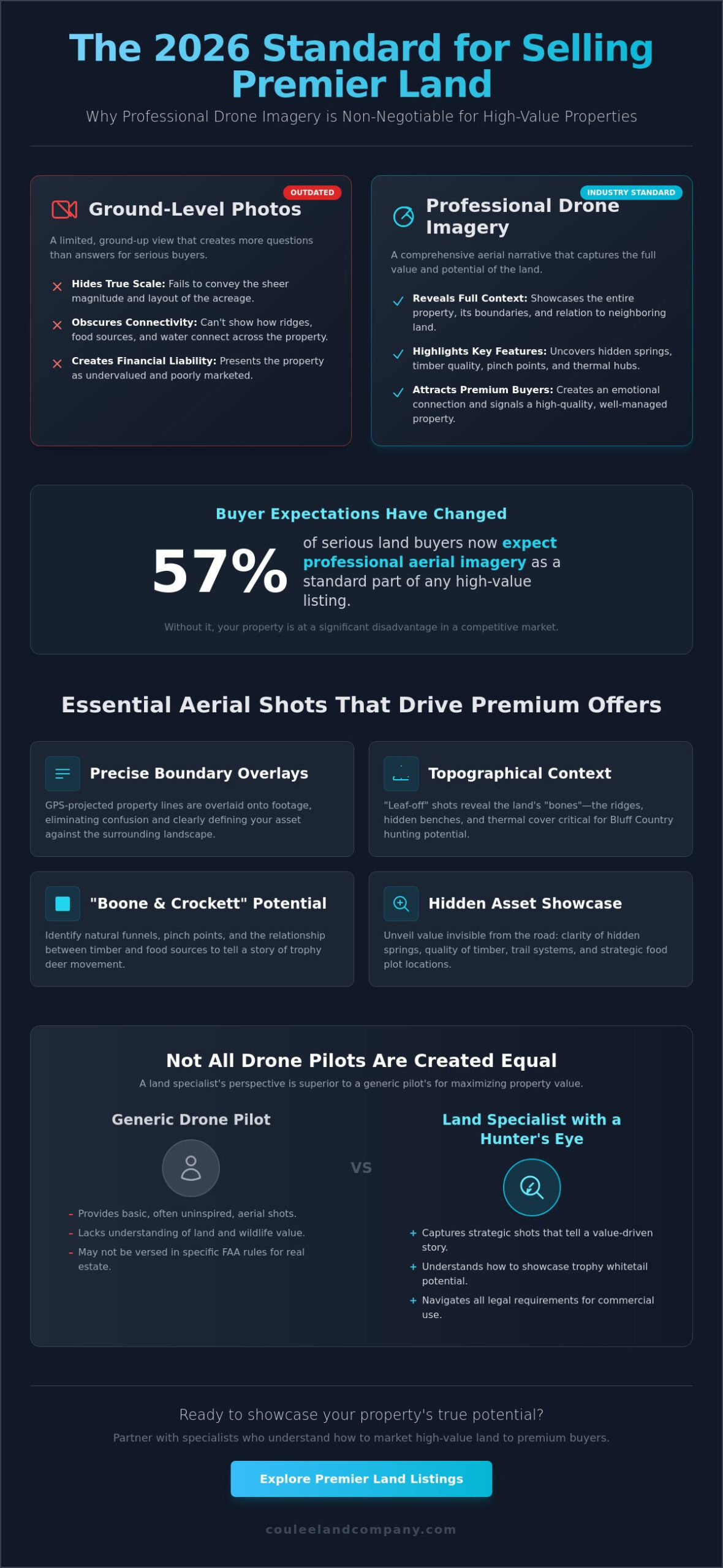
Essential Aerial Shots for High-Value Hunting and Agricultural Land
Effective drone photography for real estate land listing goes far beyond capturing a simple bird’s-eye view. In 2026, sophisticated buyers expect a visual inventory of a property’s specific assets. Boundary overlays are now a standard requirement. These overlays use GPS data to project property lines directly onto the aerial footage, showing exactly how your 40 or 160 acres sit within the broader landscape. This clarity eliminates confusion and highlights your infrastructure, such as established trail systems, existing outbuildings, or hidden food plot locations that aren’t visible from the road.
Timing is just as critical as technology. In Western Wisconsin, we prioritize “leaf-off” drone sessions during late fall or early spring. Without heavy foliage, the drone captures the raw topographical context of the land. This reveals the ridges, hidden benches, and thermal cover that define high-quality bluff country. If you want to show a buyer the true “bones” of a property, you don’t wait for summer greenery to hide the terrain.
Mapping Wildlife Potential from the Air
A property’s value often hinges on its ability to produce trophy whitetails. Aerial views allow us to identify natural funnels and pinch points that make a piece of land a “Boone and Crockett” contender. By showcasing the relationship between your timber and neighboring agricultural food sources, we tell a story of deer movement and bedding security. This perspective is essential for understanding terrain-dependent value, a concept we explore deeply in our Buffalo County hunting guide. Seeing how a ridge drops into a secluded valley helps a buyer visualize their first hunt before they even set foot on the soil.
Technical Standards for Professional Land Drones
Professional listings require professional-grade hardware. We utilize equipment capable of a minimum of 4K video and 20MP stills to ensure every image remains crisp when a buyer zooms in to inspect a creek crossing or a building site. To maintain professional standards, all pilots must strictly follow FAA regulations for real estate drones, ensuring that your marketing remains legally compliant and high-quality.
The most advanced tool in our kit is the orthomosaic map, which is created by stitching hundreds of individual photos into one massive, high-resolution file. Orthomosaic mapping is the definitive visual tool for 2026 land listings, providing a distortion-free, top-down perspective that functions as a living survey. This level of detail builds immediate trust with serious investors. If you’re looking to see how these technical standards translate to the market, browse our featured hunting properties to see the difference for yourself.
Implementing Drone Strategy: DIY vs. Hiring a Land Specialist
You shouldn’t just fly a drone over your property and call it marketing. Commercial use of drones requires an FAA Part 107 certificate. This is a non-negotiable legal requirement for any drone photography for real estate land listing. Operating without one exposes you to significant liability and potential fines from the federal government. At Coulee Land Company, we integrate a specialized aerial strategy into every seller’s marketing plan to ensure your property stands out legally and visually.
Generic pilots often miss the “Hunter’s Eye” details that sell land. They might capture a nice sunset but ignore the pinch points, thermal cover, or the specific topographical features that make a parcel a trophy whitetail destination. Our team understands the dirt because we hunt the dirt. We know that showing a bedding thicket is more valuable to a buyer than a generic shot of the clouds.
Navigating FAA Regulations and Privacy in Rural Areas
Compliance with Part 107 rules protects the landowner from liability if an accident occurs. Our insured pilots maintain strict safety protocols, including the 400-foot altitude ceiling. We also prioritize neighbor relations by using wide-angle lenses that capture your acreage without intruding on adjacent private residences. You can learn more about how our team, including experts like Mike Law, applies this hands-on land expertise to every acre we represent.
Maximizing ROI: How Drones Accelerate the Sales Cycle
Industry data from 2024 shows that land listings featuring professional aerial footage receive 300% more engagement than those with ground-level photos alone. These visuals allow remote buyers to scout hunting properties from their living rooms, effectively creating a virtual tour of the ridges and valleys. High-quality drone photography for real estate land listing often reduces time on market by 32 days compared to standard listings. This visual proof builds immediate trust with buyers who are often viewing properties from out of state.
Final Drone Shoot Preparation Checklist:
- Mark property boundaries with high-visibility flagging or stakes.
- Mow or clear main trail systems to highlight internal accessibility.
- Remove any modern debris, scrap metal, or non-essential equipment from open fields.
- Ensure gate entrances and staging areas are clean and inviting.
- Identify the specific “money shots,” such as hidden food plots or creek crossings.
Ready to showcase your property from a new perspective? Contact Coulee Land Company to see how our drone technology and land management expertise convert browsers into buyers.
Elevate Your Acreage Above the Competition
Selling a premier property in 2026 demands a visual narrative that ground-level snapshots can’t capture. High-quality drone photography for real estate land listing serves as the definitive tool for showcasing the intricate topography and hidden pinch points of Western Wisconsin’s Bluff Country. You aren’t just selling dirt; you’re selling the potential for a lifetime of memories in the woods. By highlighting timber stands and water sources from the air, you provide buyers with the tactical map they need to envision their next hunt.
Coulee Land Company brings an unmatched level of expertise to every sale. We specialize in Buffalo County properties, a region that consistently dominates the Boone and Crockett Record Book for trophy whitetail entries. Our marketing strategy utilizes FAA-compliant aerial technology and carries the weight of endorsements from industry-leading outdoor television hosts. This professional edge ensures your property stands out to serious land managers and sportsmen alike.
Maximize your property’s value; List with the Western Wisconsin Land Specialists
Your land deserves a representation as legendary as the bucks that roam it.
Frequently Asked Questions
Do I really need an FAA license to take drone photos of my own land for sale?
You must hold a Part 107 Remote Pilot Certificate from the FAA to use drone photography for real estate land listing purposes, even on your own property. The FAA classifies any flight intended to further a business, such as selling a 40 acre hunting tract, as a commercial operation. Since the 2016 implementation of these rules, failing to hold a license can result in civil penalties exceeding $32,000 per violation for both the pilot and the landowner.
What is the best time of day to take drone photos of a land listing?
The optimal time for capturing land listings is during the golden hour, which occurs roughly 60 minutes before sunset or after sunrise. This low sun angle creates long shadows that define the rugged ridges and deep coulees of Western Wisconsin. We recommend shooting when the sun is at an elevation of 10 to 15 degrees. This specific lighting ensures the topography of your timber or tillable acreage is clearly visible to prospective buyers.
How much does professional drone photography for land usually cost?
Professional drone photography for real estate land listing typically costs between $150 and $500 per session according to 2024 industry data from service platforms like Thumbtack. These rates depend on the total acreage and the number of high resolution 4K images required. High end packages for large 100 plus acre estates often include edited aerial video and orthomosaic mapping. These tools provide a comprehensive view of the property’s layout and wildlife habitat capabilities.
Can drone photography help with property tax assessments or land management?
Drone imagery assists with land management by providing high resolution orthomosaic maps that offer 2 to 3 centimeters of accuracy per pixel. These maps allow owners to calculate exact tillable acreage or timber density. This data is critical for accurate property tax assessments and Managed Forest Law applications. By documenting land improvements like food plots or new access roads, you create a visual record that supports valuation and long term conservation goals for your property.